Indiana Severe Weather Preparedness Week

March 14 is the beginning of the Indiana Storm Preparedness Week and to kick thing off here's a short post about what you can do to prepare.

The National Weather Service (NWS) puts on Spotter Training presentation across Indiana and hopefully you are able to attend one that is put on near your home. I recently attended the Monroe County presentation in Bloomington during the February Bloomington Amateur Radio Club meeting on March 2nd. Dave Tucek an Indianapolis NWS meteorologists told the 100 or so people gathered about forecast Outlooks, Watches and Warnings and how to use that information to prepare yourself and family in the event that severe weather develops. He talked at length about how to interact with NWS either by phone or social media which is playing an increasingly important role in storm spotting and helping the NWS stay informed about what is happening on the ground. I highly recommend attending a Storm Spotter Training session and one is coming up in Brown county on April 24th at the Brown County Law Enforcement Center 55 State Road 46 E, Nashville, IN (map) where you are able to get all the facts and details directly from a National Weather Service meteorologist.

Here's a link where you can check all upcoming sessions NWS Indianapolis Spotter Training

Two interesting and informative products that the Indianapolis NWS produces that are the

Hazardous Weather Outlook
Local Forecast

With a little investigation and browsing you can discover that here much more that the National Weather Service provides including detailed online Severe Weather Skywarn training where you can take online quizzes to test your comprehension of the material.

Check out the 4 modules listed below here http://www.weather.gov/lmk/spottertraining

Module 1 - Introduction
Module 2 - How The Weather Works
Module 3 - Storm Spotting
Module 4 - Information Exchange

Each day during the Indiana Severe Weather Prepardness I will blog about activities going on that day. Here are the topics the posts will cover

Sunday: Kick-Off: Discuss partners' roles in severe weather
Monday: Severe Weather Outlooks and Watches: Partners' roles at the outlook and watch stages of an event
Tuesday: Warnings: Taking action when warnings are issued (Statewide Tornado Drill Day)
Wednesday: Response: Partners' roles in responding to disasters (real-time response)
Thursday: Recovery: Partners' roles in the recovery process (days/weeks/months after disaster)
Friday: Weather Ready Nation: How we are working to build a Weather Ready Nation
Saturday: Wrap-Up: Importance of preparedness and action during threatening hazards

Please read the Preparedness Week brochure for details. Click here (6.6MB pdf) for a kids' activity booklet from the Indiana Department of Homeland Security.

What should you do at each step as severe weather threatens:

Think READY (outlook), SET (watch), GO (warning)!
Outlook (hours to days in advance)
Watch (minutes to hours in advance)
Warning (event is threatening now)?

NWS Indianapolis Storm Spotter Training in Brown County

The Indianapolis National Weather Service relies on trained volunteers to supplement radar information during a severe storm or tornado event.

This program is open to the public and will provide information about severe thunderstorm development and identification of important features as well as safety tips and more.


6:30pm Tuesday, April 24th 2018
Brown County Law Enforcement Center
55 E State Road 46
Nashville, IN

This is a FREE training and NO pre-registration is required

For more information contact: Brown County Emergency Management at (812) 988-2063 Or by email This email address is being protected from spambots. You need JavaScript enabled to view it.

National Weather Service Storm Spotter Training in Brown County

ARES Connect information from Dale Williams, WA8EFK Chairman of the ARRL Public Service Enhancement Working Group regarding ARES Connect

"The Amateur Radio Emergency Service (ARES) has been the public service communication program of the ARRL since 1935. Over many years and following many natural disasters, volunteers in our field organizations have provided us with a lot of valuable feedback about the ways we could improve and modernize (including adapting to new communication modes) to make this organization work more efficiently and effectively.
The ARRL Board of Directors created a working group to look at the input from volunteers in the field organization, as well as incorporating the work of previous committees studying improvements to ARRL public service programs, to develop strategies to enhance the professionalism and consistency of the ARES program and those who are part of it
The working group recognized that there is a strong need for a robust volunteer management system to connect field organizations to training, resources, and information from ARRL. Other improvements that will be rolled out in the months ahead include establishment of national training requirements and improved local training resources, updated ARES operating guidelines, and updated field organization job descriptions.
A few weeks ago, an announcement went out outlining the changes coming to the ARES program. The first of these changes, establishing ARES Group IDs, is now ready. Before we get into the instructions on how to register your ARES group, we first want to cover some basic questions on how the ID relates to this new volunteer management system ARES Connect.

What is ARES Connect?
ARES Connect is a volunteer management system that will allow each ARES group to manage their roster, create and staff events, and track nets and training. Each ARES group and ARRL Section will have a unique page on the platform with appropriate admin control given to the ARES Emergency Coordinator.
ARES members will be able to create a user profile that connects them to their local ARES group. Through their profile they can register for ARES (pending EC approval), sign up for events, log volunteer hours, and log training.
Reporting will be different through ARES Connect. As users log activity, data is created that allows ECs, DECs and SECs to run custom reports. The current ARES report forms will continue to be used through 2018 as the system is being built, but our current plan is to shift all reporting over to ARES Connect in January 2019.
Beta testing of the platform will begin in early 2018. Look for more information to be released about ARES Connect around midyear, once testing and initial build is complete."

Brown County Field Day 2017 at Weatherford Forest

https://www.google.com/maps/@39.2814526,-86.2262285,255m/data=!3m1!1e3

 100 acres to spread our spectrum over

ARRL Field Day is the single most popular on-the-air event held annually in the US and Canada.  On the fourth weekend of June of each year, more than 35,000 radio amateurs gather with their clubs, groups or simply with friends to operate from remote locations.

Field Day is a picnic, a campout, practice for emergencies, an informal contest and, most of all, FUN!

It is a time where many aspects of Amateur Radio come together to highlight our many roles. While some will treat it as a contest, other groups use the opportunity to practice their emergency response capabilities.  It is an excellent opportunity to demonstrate Amateur Radio to the organizations that Amateur Radio might serve in an emergency, as well as the general public. For many clubs, ARRL Field Day is one of the highlights of their annual calendar.

The contest part is simply to contact as many other stations as possible and to learn to operate our radio gear in abnormal situations and less than optimal conditions.

We use these same skills when we help with events such as marathons and bike-a-thons; fund-raisers such as walka-thons; celebrations such as parades; and exhibits at fairs, malls and museums — these are all large, pre-planned, non-emergency activities.

But despite the development of very complex, modern communications systems — or maybe because they ARE so complex — ham radio has been called into action again and again to provide communications in crises when it really matters. 

Amateur Radio people (also called “hams”) are well known for our communications support in real disaster and post-disaster situations.

What is the ARRL?

The American Radio Relay League is the national association for Amateur Radio in the USA, representing over 171,000 FCC-licensed Amateurs. The ARRL is the primary source of information about what is going on in ham radio. It provides books, news, support and information for individuals and clubs, special events, continuing education classes and other benefits for its members.   

What is Amateur Radio

Often called “ham radio,” the Amateur Radio Service has been around for a century. In that time, it’s grown into a worldwide community of licensed operators using the airwaves with every conceivable means of communications technology. Its people range in age from youngsters to grandparents.  Even rocket scientists and a rock star or two are in the ham ranks.  Most, however, are just normal folks like you and me who enjoy learning and being able to transmit voice, data and pictures through the air to unusual places, both near and far, without depending on commercial systems.  

The Amateur Radio frequencies are the last remaining place in the usable radio spectrum where you as an individual can develop and experiment with wireless communications.  Hams not only can make and modify their equipment, but can create whole new ways to do things.


RIP Pete 'KA9SWI' Lenges

One thing we will always cherish,
No matter what life sends.
A memory of the happiness
Just being friends.
A page in the book of memory
Silently turns today.
We remember you in silence,
And make no outward show.
And what it meant to lose you
No one will ever know.

Brown County Democrat Obituary

Peter J. Lenges III, 72, of Nineveh, died Friday, April 21, 2017 in Nineveh.

He was born Oct. 23, 1945, to Joseph and Opal (Brunson) Lenges, in Corpus Christi, Texas.

He was an Army veteran and worked as an electrical engineer at Crane Naval Center for 25 years. He enjoyed being a ham radio operator and was well known for that in his community. Peter liked working on genealogies and coin collecting. He was a firearm and Mopar enthusiast. Peter loved fishing, hunting, and all varieties of hot sauce.

He is survived by his wife, Jewell (Corbin) Lenges of Nineveh; his son, Peter (Tina) Lenges IV. of Carmel; four grandchildren; and two great-grandchildren.

Peter was preceded in death by a son, Timothy Lenges.

A funeral service at 7 p.m. Thursday, April 27, will be conducted by Chaplain Don Sanders at Jessen Funeral Home, Whiteland Chapel, 729 N. U.S. Highway 31.

The family will host visitation from 4 p.m. until the service at the funeral home.


NWS Indianapolis Storm Spotter Training in Brown County

The Indianapolis National Weather Service relies on trained volunteers to supplement radar information during a severe storm or tornado event.

This program is open to the public and will provide information about severe thunderstorm development and identification of important features as well as safety tips and more.


6:30pm Monday, May 15th 2017
Brown County Law Enforcement Center
55 E State Road 46
Nashville, IN

This is a FREE training and NO pre-registration is required

For more information contact: Brown County Emergency Management at (812) 988-2063 Or by email This email address is being protected from spambots. You need JavaScript enabled to view it.

National Weather Service Storm Spotter Training in Brown County

Warnings – Take Action!

 The National Weather Service will issue Test Tornado Warnings Tuesday between 10:00a.m. and 10:30 a.m., and again between 7:30 p.m. and 8:00 p.m.  It’s everyone’s job in these drills to test your tornado plans, seeking safe shelter areas.  Review your actions and amend your safety plans if needed.

Brown County Amateur Radio operators plan on conducting a test SKYWARN net this evening on the Brown County 147.300MHz 2 meter repeater at 7:30 p.m.  During this test a "Net Control Station" begins the net and checks in  participating Hams gathering information from them including their Calll Sign, their location and if they are operating on a base station or mobile.  During the net the amateur radio operator report back to Net Control any severe weather events they witness.   That information is relayed through a single amateur radio operator in Brown County who has been designated "Liaison" to another much broader net that is run on the Indianapolis 146.970MHz repeater and covers many counties in central and southern Indiana and is directly monitored by the National Weather Service office in Indianapolis. 

Often you hear on TV or the radio that a "Trained Spotter has reported....."  Quite often that is an amateur radio operator BUT you do not have to be a Ham to become a Trained Spotter.  In fact anyone can become a Trained Spotter either by attending one of the Indianapolis National Weather Service Spotter Training's near you or taking an online course available through MetEd/Comet.  At the Spotter Training you will learn how to contact the NWS and what information you would like for you to submit.   You can all them directly (317) 856-0664, submit a report online or via Facebook or even Twitter using @NWSIndianapolis

As they have done every day this week the NWS Indianapolis office has created a document for you to review, today's may be the most important of all

Have a look at it here http://www.weather.gov/media/ind/PrepWeeks/Severe/TueFactsWarnings.pdf

Here are a few highlights but be sure to read the entire document

  • You…Be a Force of Nature! Be Weather Ready!
    • Take Action: be an example for others, taking cover, along with your pin designated storm resistant locations
  • The National Weather Service
    • Issues official Warnings when dangerous, damaging weather is immminent and Activates NOAA All-Hazards radio and the Emergency Alert System, sounding alarms on radios, media stations, and pre-set electronic de  Receives damage reports from spotters and relays reports to the media
  • Local Officials
    • Activate Outdoor Warning sirens; deploy responders to damage areas
  • Indiana Department of Homeland Security
    • Activates Emergency Operations Center, coordinates with local officials
  • The American Red Cross
    • May deploy to the IDHS Emergency Operations Center
  • The Media
    • Broadcasts NWS warnings/crawl TV text message; Facebook/Tweet


Welcome to Spring and Severe Weather Season


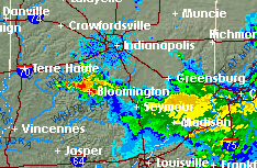
Spring began today at 6:29 AM and Mother Nature wasted no time in kicking things off with a nice Thunderstorm sweeping across central Indiana.  While not severe they did issue a "Special Weather Statement" for Owen, Brown and Monroe counties advising that dime size hail was possible.

Todays topic "Severe Weather Outlooks and Watches" is very appropriate and fully described in a document they have written

Here are a few highlights from their document about what you can do and what NWS partner provides information to help you understand and respond to severe weather events.

  • You. Be Weather Ready. Know Your Risk.
    • Develop a plan.  Encourage others to develop a plan
  • National Weather Service
    • Issues Hazard Outlooks, identifying weather or flood risks out 7-14 days
  • Indiana Department of Homeland Security 
    • Develops preparedness plans in coordination with local officials
  • The American Red Cross 
    • Alerts trained disaster volunteers to be prepared for possible response
  • Schools, Local Safety Officials and Responders  
    • Monitors NWS Outlooks to determine need for hazard preparations
  • The Media 
    • Local TV meteorologists begin broadcasting concerns for severe weather threats

To view NWS Watches, Warnings and Advisories you can find up to date information here

To view a radar image loop of weather as it develops visit the Indianapolis NWS website for an interactive map

Weather Underground also offers near time radar images and loops on their website

As always stay alert to changing weather conditions and consider loading up a Weather app on your phone, many are free and it could be that your wireless provider is already supplying information to your phone. 

You can read the full story here to see if your wireless provider has this feature